|
Tuesday July 9
 Finally, after Glen Falls, we headed on
over to Franconia, NH to the Westwind
Cottages. This is
definitely the low budget option, but perfectly adequate.
The exteriors of the cottages are rather run down, e.g., our storm door
isn’t mounted correctly so
it doesn’t close, but we have a nice one room cottage (Dryad) with a
large dorm
size fridge, microwave, toaster oven and flat screen TV (I feel some
West Wing coming tonight). The inside is very nicely done;
a new black lounging chair; black and white decor (spread,
towels). Dishes, silverware, glasses are included.
It’s small but enough for us, and the internet works!
The lighting is poor – you can’t actually read
by any of the lights in the
room and it would be really nice if there was a small bedside table on
both sides. But really, the location and cost are perfect. Finally, after Glen Falls, we headed on
over to Franconia, NH to the Westwind
Cottages. This is
definitely the low budget option, but perfectly adequate.
The exteriors of the cottages are rather run down, e.g., our storm door
isn’t mounted correctly so
it doesn’t close, but we have a nice one room cottage (Dryad) with a
large dorm
size fridge, microwave, toaster oven and flat screen TV (I feel some
West Wing coming tonight). The inside is very nicely done;
a new black lounging chair; black and white decor (spread,
towels). Dishes, silverware, glasses are included.
It’s small but enough for us, and the internet works!
The lighting is poor – you can’t actually read
by any of the lights in the
room and it would be really nice if there was a small bedside table on
both sides. But really, the location and cost are perfect.The camp stove in the picture is ours. I know it's not safe to use it indoors without serious precautions - the window just above it is open. And it's raining out... again. Wed July 10, 2013  This morning after
breakfast we made our way to the trailhead for the
hike to Bridal Veil Falls. That was a little complicated
because we got north and south mixed up on exiting the
cottages. ;) But the
instructions were good once we sorted out our confusion! This morning after
breakfast we made our way to the trailhead for the
hike to Bridal Veil Falls. That was a little complicated
because we got north and south mixed up on exiting the
cottages. ;) But the
instructions were good once we sorted out our confusion!The hike was about 2.5 miles each way. We started out on a road from the parking area to the Coppermine Trail; then a nice smooth pine-needle-covered wide trail. Then it became strewn with medium sized rocks, and got steeper and wetter, though none of it was as rigorous as the Lye Brook trail. We crossed the Coppermine Brook on a bridge, then passed a hiking shelter; then had to cross the Brook on rocks and finally we were there (about an hour and 40 minutes). The falls (pictured above) were stunning. There was no place to sit except on boulders but that was okay; we were the only ones there and we enjoyed the falls and pool while we had lunch. Below, left to right: Coppermine Brook, Barb having lunch and the hiking shelter along the trail. 

 We stopped at Mac’s Groceries on the way home and picked up some supper supplies and some Ben & Jerry’s since we actually have a freezer here that works! Tastes great after a long hike! After we got back to the cottage, it poured; but the timing was good - we were indoors! John fixed supper - pork chops with maple cream sauce and apple/sweet potatoes mix. Very yummy. We watched a couple episodes of West Wing and went to bed early. Thurs July 11   It
was pouring again when we woke this morning - gee, something new
and different! John fixed pancakes and the rain was
down to a trickle by the time we headed out to Franconia State Park.
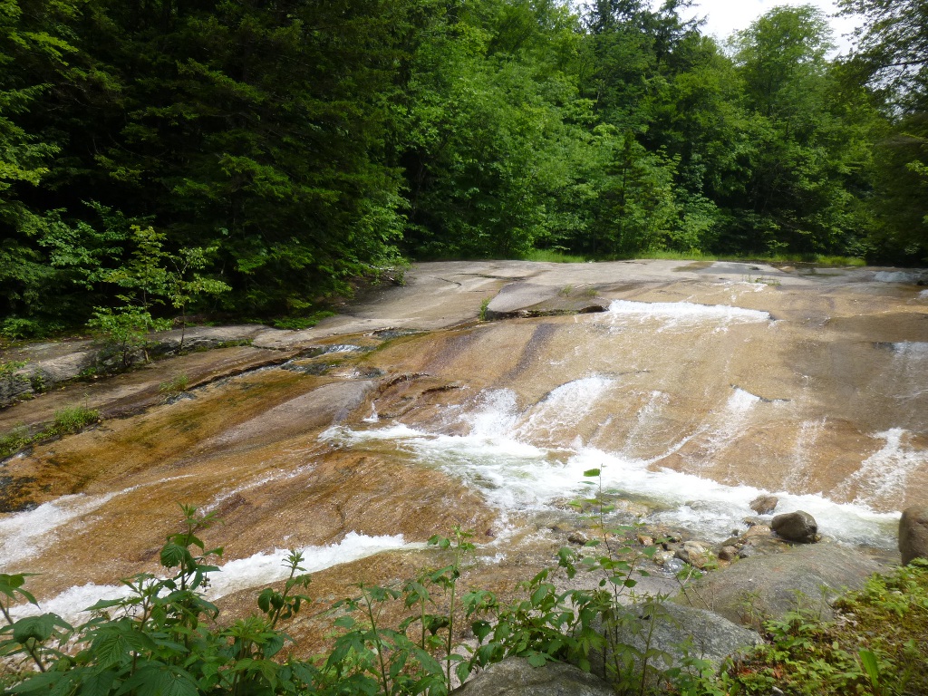
Our first stop was the
Basin (on the right) - accessible by a large, paved trail.
On the way from the parking lot, we walked along the Pemigawasset River
and passed some small falls (left). The Basin is a
rock
formation (said to be 25,000 years old) that created a 20 foot pothole
and results in some interesting currents and cascades. But
the
real treat at this location was walking up the Basin-Cascades Trail,
towards Kinsman Falls, along the Cascades
Brook for a quarter of a mile or so. It
was pouring again when we woke this morning - gee, something new
and different! John fixed pancakes and the rain was
down to a trickle by the time we headed out to Franconia State Park.
Our first stop was the
Basin (on the right) - accessible by a large, paved trail.
On the way from the parking lot, we walked along the Pemigawasset River
and passed some small falls (left). The Basin is a
rock
formation (said to be 25,000 years old) that created a 20 foot pothole
and results in some interesting currents and cascades. But
the
real treat at this location was walking up the Basin-Cascades Trail,
towards Kinsman Falls, along the Cascades
Brook for a quarter of a mile or so.  Today the trail had pretty much turned
into a
stream, or just tree roots where the trail had completely eroded away
(pictured left), but it was so worth it to wade/climb up! Today the trail had pretty much turned
into a
stream, or just tree roots where the trail had completely eroded away
(pictured left), but it was so worth it to wade/climb up!  There
are flood
warnings out
this morning and apparently a bridge across the brook further up has
washed out. It was easy
to see why – this little brook was HUGE. As we climbed up the
trail, the brook was on our left and periodically we forged our way
over to it to get views of the falls and cascades. One of the
early pictures is at the right, as the brook spread out more and didn't
look so wild. There
are flood
warnings out
this morning and apparently a bridge across the brook further up has
washed out. It was easy
to see why – this little brook was HUGE. As we climbed up the
trail, the brook was on our left and periodically we forged our way
over to it to get views of the falls and cascades. One of the
early pictures is at the right, as the brook spread out more and didn't
look so wild. As we hiked upwards, it got more and more vigorous - the waves splashing down looked like heavy surf at the ocean! Where John is standing was not as dangerous as it looks - there's a huge wide rock there and the brook is directed away from it, making it a great vantage point for picture taking! We didn't get all the way to Kinsman Falls (I'm not sure we could have today) but the roaring falls in the center were fun to watch; the final picture on the right is above those falls. We had loads of beautiful views and enjoyed the scenery tremendously.  
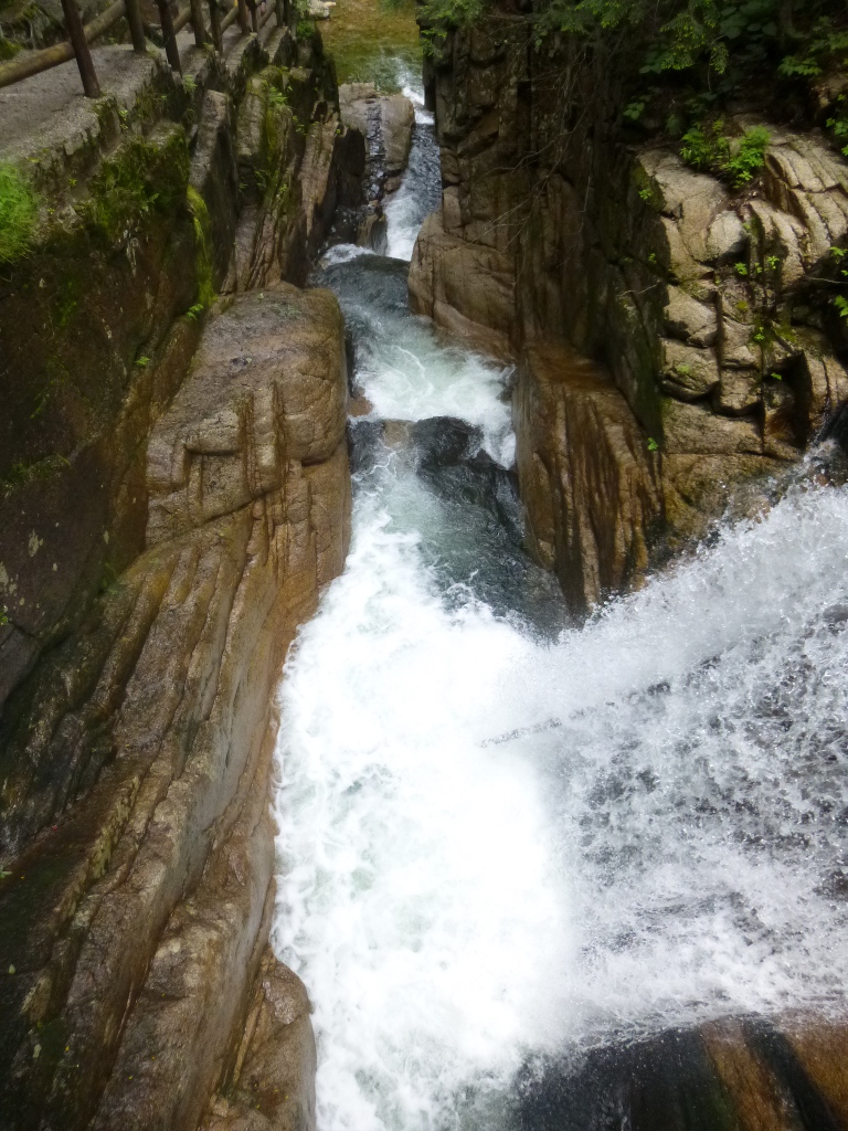
  Next we drove down to Flume Gorge.
There is a $15 admission fee
but we felt it was worthwhile. (If you want to do both the
Flume
Gorge and the Cannon Mountain Aerial Tram, you can buy a combination
ticket that saves $5.) We walked the whole 2 mile
loop -
the scenery is quite varied. Besides the gorge, there
are covered bridges, lots of
history and geology (including a 300 ton boulder), some shelters,
rocks, falls. At left is Table Rock - a huge section of
Conway
Granite in Flume Brook. Shortly after passing Table Rock, we enter the
very narrow Flume Gorge (left below). In the center is a
sample
of the sides of the gorge - it's clearly a very wet environment and
supports many different kinds of vegetation. The main
attraction is
Avalanche Falls, on the right, as it tumbles down and then pours
through the narrow gorge shown at the left. Next we drove down to Flume Gorge.
There is a $15 admission fee
but we felt it was worthwhile. (If you want to do both the
Flume
Gorge and the Cannon Mountain Aerial Tram, you can buy a combination
ticket that saves $5.) We walked the whole 2 mile
loop -
the scenery is quite varied. Besides the gorge, there
are covered bridges, lots of
history and geology (including a 300 ton boulder), some shelters,
rocks, falls. At left is Table Rock - a huge section of
Conway
Granite in Flume Brook. Shortly after passing Table Rock, we enter the
very narrow Flume Gorge (left below). In the center is a
sample
of the sides of the gorge - it's clearly a very wet environment and
supports many different kinds of vegetation. The main
attraction is
Avalanche Falls, on the right, as it tumbles down and then pours
through the narrow gorge shown at the left. 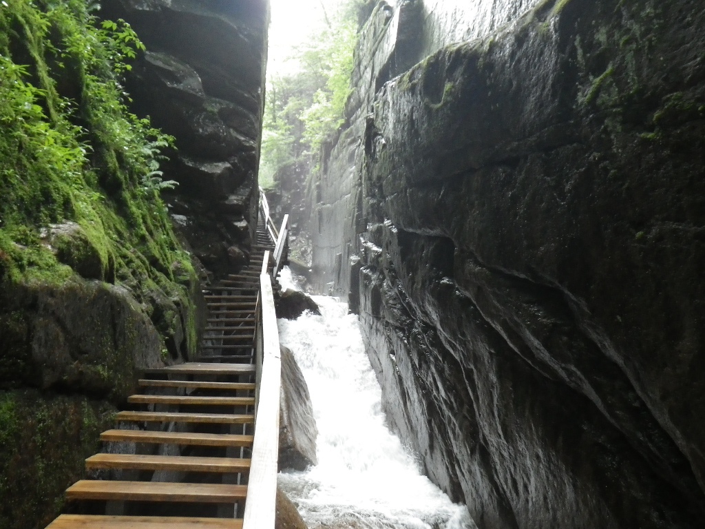

 Continuing along the trail, we came to various other sites including Liberty Gorge (falls at left below). The center picture shows John on the Sentinel Bridge just past the Liberty Gorge and then his view of the Pemigawasset River below the bridge. This was definitely a good week for waterfalls – all of the creeks, rivers and brooks are unseasonably full! 

   We had lunch at the picnic area there
at the Flume Visitor Center and
then headed back north. At left is a view of some of the White
Mountain peaks: Mt. Liberty, Mt. Flume and Mt. Osseo. We
stopped
at Boise Rock (right) for a short walk and some views of Cannon Cliffs
and Profile Lake. Boise Rock is named for Thomas Boise who
sought
shelter under the rock during a storm and used his horse's hide as
warmth to save his life around 1800. We had lunch at the picnic area there
at the Flume Visitor Center and
then headed back north. At left is a view of some of the White
Mountain peaks: Mt. Liberty, Mt. Flume and Mt. Osseo. We
stopped
at Boise Rock (right) for a short walk and some views of Cannon Cliffs
and Profile Lake. Boise Rock is named for Thomas Boise who
sought
shelter under the rock during a storm and used his horse's hide as
warmth to save his life around 1800.   It
had been overcast and drizzling all day so we hadn't planned to go up
Cannon Mountain, thinking we wouldn't be able to see anything.
But, as we headed north again, we spotted sun and made the
snap
decision to
stop at Cannon Mountain. I'm so glad we did! We
took the
Aerial Tramway up to the top ($15), then walked the last little
bit
up to the
observation tower on Kinsman Ridge Trail. (A returning Tram
is
shown at the left and a view from the Tram on the way up on the
right.) It was great; the sun came out and we could see about
60
miles or so from the
summit. There are several walking trails in the area and we
enjoyed the scenery and the plants for a while. On the way
back
down we saw a mother black bear with 2 cubs out on one of the ski
trails. Of course, my camera wasn’t ready so I missed the
shot. But it was a great treat nonetheless. Below
is a
posed picture of us along Kinsman Ridge Trail and a distance view from
the observation tower. It
had been overcast and drizzling all day so we hadn't planned to go up
Cannon Mountain, thinking we wouldn't be able to see anything.
But, as we headed north again, we spotted sun and made the
snap
decision to
stop at Cannon Mountain. I'm so glad we did! We
took the
Aerial Tramway up to the top ($15), then walked the last little
bit
up to the
observation tower on Kinsman Ridge Trail. (A returning Tram
is
shown at the left and a view from the Tram on the way up on the
right.) It was great; the sun came out and we could see about
60
miles or so from the
summit. There are several walking trails in the area and we
enjoyed the scenery and the plants for a while. On the way
back
down we saw a mother black bear with 2 cubs out on one of the ski
trails. Of course, my camera wasn’t ready so I missed the
shot. But it was a great treat nonetheless. Below
is a
posed picture of us along Kinsman Ridge Trail and a distance view from
the observation tower.
 We got back at the cottage around 4 PM; I did some laundry while John drove a mile or so to get a phone signal and make some calls. I’m on for supper tonight – ground beef stroganoff with zucchini and some leftover potato salad. Tomorrow we'll be heading for the eastern side of the mountains. Friday July 12 - We left before 10 this morning – we are definitely not early birds! Our route took us down US 302 and past several waterfalls so of course, we had to stop.   Flume
Cascade was right by the highway. We spent some time
climbing up the rocks just for fun, as well as some different views.
I liked the one at left where you could see 3
different
"falls" coming together in a pool before they tumbled down to the
bottom. At the parking area across the street, there was also
a
short path to
the "Dismal Pool." I’m not sure what was supposed to be
dismal
about
it – it was just a small pool but the sun was in the right place so the
reflections were lovely. At the right, I was getting ready to
take my own picture of it! The next stop was at the Silver
Cascade (below left). Flume
Cascade was right by the highway. We spent some time
climbing up the rocks just for fun, as well as some different views.
I liked the one at left where you could see 3
different
"falls" coming together in a pool before they tumbled down to the
bottom. At the parking area across the street, there was also
a
short path to
the "Dismal Pool." I’m not sure what was supposed to be
dismal
about
it – it was just a small pool but the sun was in the right place so the
reflections were lovely. At the right, I was getting ready to
take my own picture of it! The next stop was at the Silver
Cascade (below left). 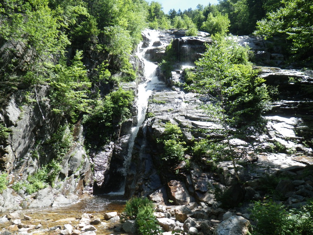 It
was also quite pretty and close enough to the road there was no hike
involved to get to it, but again, we climbed up the side on the rocks
and enjoyed the different perspectives. It
was also quite pretty and close enough to the road there was no hike
involved to get to it, but again, we climbed up the side on the rocks
and enjoyed the different perspectives.  The
picture to the right was taken from the parking lot for Ripley Falls.
I don't know what peak it is but I thought the view was
lovely
and couldn't resist. The trail to the falls starts out
crossing a
railroad track and a sign warning people that the tracks are in use so
use caution. We looked both ways. The
picture to the right was taken from the parking lot for Ripley Falls.
I don't know what peak it is but I thought the view was
lovely
and couldn't resist. The trail to the falls starts out
crossing a
railroad track and a sign warning people that the tracks are in use so
use caution. We looked both ways.   It
was less than a mile up to the falls but parts were rather
steep and I apparently injured my ankle
yesterday. It's
not bad when I'm walking on flat ground, but bending it to
climb steep trails was fairly painful. The scenery
along the
trail was very nice, however - once again, we saw lots of rivulets and
small falls all along the trail - one such spot is at the
left. It
was less than a mile up to the falls but parts were rather
steep and I apparently injured my ankle
yesterday. It's
not bad when I'm walking on flat ground, but bending it to
climb steep trails was fairly painful. The scenery
along the
trail was very nice, however - once again, we saw lots of rivulets and
small falls all along the trail - one such spot is at the
left. 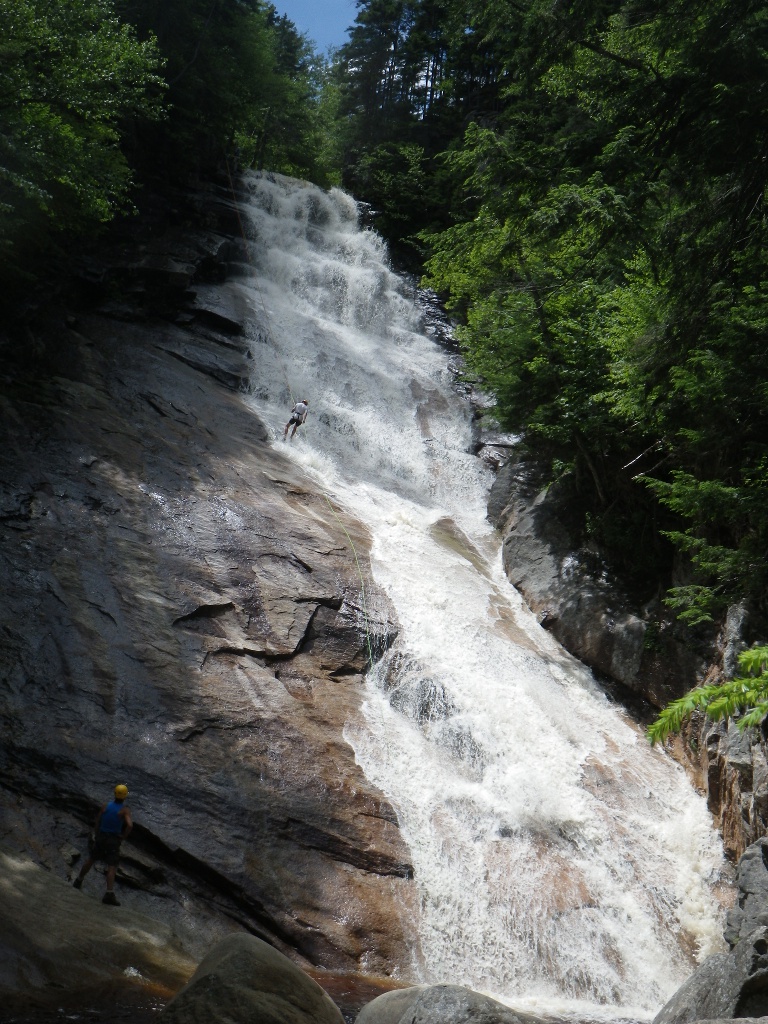 Ripley
Falls is about 100 feet of awesome! You really can see how
large
it is by the size of the person rappelling down in the picture at the
right. (If you can't see him, or the one waiting at the bottom to the
left of the falls, click to enlarge it.) We had our picnic
lunch
by the falls while we watched several guys taking turns going
down
and spotting each other (and I rested my ankle) and then we hiked back
down for one more stop. Ripley
Falls is about 100 feet of awesome! You really can see how
large
it is by the size of the person rappelling down in the picture at the
right. (If you can't see him, or the one waiting at the bottom to the
left of the falls, click to enlarge it.) We had our picnic
lunch
by the falls while we watched several guys taking turns going
down
and spotting each other (and I rested my ankle) and then we hiked back
down for one more stop.We postponed the falls that required a longer, steep hike out of deference to my ankle and instead went to Diana's Baths. It’s a White Mountain National Park site with a $3 parking fee (but a National Park Senior Pass is accepted for that). The trail from the parking lot was quite accessible: flat and wide and therefore, kind to unhappy ankles. What an amazing place! I called it God’s waterpark! It was packed with families and kids romping all over the rocks, playing in the pools and the falls. It was so full today on a Friday that I don’t want to even think what it would be like on a weekend! I am rather surprised that the Park Service just has a couple of Caution signs up - I would have guessed they would try to close it off due to liability issues. But I'm glad they haven't as it is such a neat place! Three views of the area below - falls, pools, cascades, lots of rocks to climb on. 

  On
the way to Dianas Baths we passed through Bartlett, NH where we saw
Josiah
Bartlett Elementary School! In spite of the extra "t" he is
supposed to have been
an ancestor of the fictional President Bartlet on West Wing who is my
idol. So I had to look him up and I learned that he was a
delegate to the Continental
Congress from NH and signed the Declaration of Independence right after
Jefferson. Who knew?? He was a physician, a
governor of NH,
a chief
justice of the state supreme court and the first President of the NH
Medical Society. On
the way to Dianas Baths we passed through Bartlett, NH where we saw
Josiah
Bartlett Elementary School! In spite of the extra "t" he is
supposed to have been
an ancestor of the fictional President Bartlet on West Wing who is my
idol. So I had to look him up and I learned that he was a
delegate to the Continental
Congress from NH and signed the Declaration of Independence right after
Jefferson. Who knew?? He was a physician, a
governor of NH,
a chief
justice of the state supreme court and the first President of the NH
Medical Society.  On
the way back to Will's Inn from the Baths, we passed a wonderful
strawberry stand - they had fresh berries, jams and other berry
products at very reasonable costs. So we stopped and bought some
(it's even a drive-through) and I took a picture of scenic Cathedral
Ledge (right) across the street. We got to Will’s
Inn around
3:30 PM. Our room (#2) is nice. It's larger than
the
cottage at Westwind (also slightly more expensive). They
have a
fridge and microwave and there are grills and picnic tables to share
but no dishes or cooking tools. Since we’ve been
camping, we
have all the stuff we need – and the room does have a nice,
convenient counter that holds our camp cupboard, the microwave and
still leaves room
for food preparation. The TV is gigantic, but not HDMI
compatible
so no West Wing or movies tonight. On
the way back to Will's Inn from the Baths, we passed a wonderful
strawberry stand - they had fresh berries, jams and other berry
products at very reasonable costs. So we stopped and bought some
(it's even a drive-through) and I took a picture of scenic Cathedral
Ledge (right) across the street. We got to Will’s
Inn around
3:30 PM. Our room (#2) is nice. It's larger than
the
cottage at Westwind (also slightly more expensive). They
have a
fridge and microwave and there are grills and picnic tables to share
but no dishes or cooking tools. Since we’ve been
camping, we
have all the stuff we need – and the room does have a nice,
convenient counter that holds our camp cupboard, the microwave and
still leaves room
for food preparation. The TV is gigantic, but not HDMI
compatible
so no West Wing or movies tonight. Saturday July 13 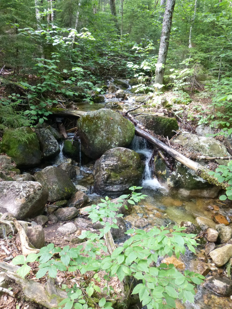 We had considered
Arethusa Falls yesterday afternoon but that trail is very steep and my
ankle was getting painful so we decided to wait and do that today
when I am fresh. I took an ibuprofen in the morning and
wrapped it under the sock with my elastic ankle brace. Then
I took another ibuprofen as we started back down from
Arethusa, and it behaved beautifully! We had considered
Arethusa Falls yesterday afternoon but that trail is very steep and my
ankle was getting painful so we decided to wait and do that today
when I am fresh. I took an ibuprofen in the morning and
wrapped it under the sock with my elastic ankle brace. Then
I took another ibuprofen as we started back down from
Arethusa, and it behaved beautifully! Today was hot (well, by NH standards:
in the mid-80’s) and sunny. We bought yummy sandwiches at
White
Mountain Cider Co down the road (I had a hummus, avocado,
tomato and
spinach rollup) and set off for Arethusa Falls. The parking
lot was nearly full at 9:30 AM which told us a lot. Today was hot (well, by NH standards:
in the mid-80’s) and sunny. We bought yummy sandwiches at
White
Mountain Cider Co down the road (I had a hummus, avocado,
tomato and
spinach rollup) and set off for Arethusa Falls. The parking
lot was nearly full at 9:30 AM which told us a lot. The trail started out crossing the same railroad tracks we crossed yesterday but about 2 miles further east. The picture on the left above captures some of the scenery along the trail. It was only about 1.5 miles to the falls but a strenuous trek for us. It was very steep and the latter half was very muddy – though not with water running down the trail like we had on the Basin-Cascades trail. 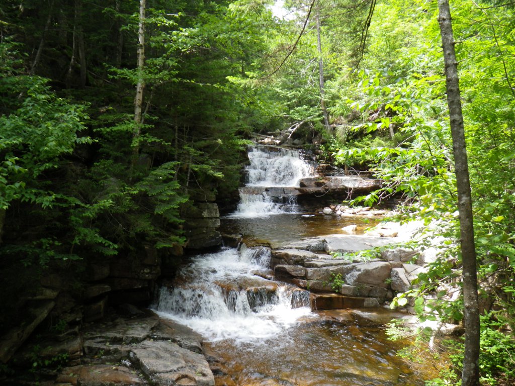 But oh my, when you reach the top, what
a gorgeous falls (to the right above)! Even with a fairly
wide angle lens, I had to stay way back to get the whole falls in the
picture. I was amazed at the people who made that hike in
flip flops; and all of the little kids. My, I am definitely
out of shape. But oh my, when you reach the top, what
a gorgeous falls (to the right above)! Even with a fairly
wide angle lens, I had to stay way back to get the whole falls in the
picture. I was amazed at the people who made that hike in
flip flops; and all of the little kids. My, I am definitely
out of shape.We were there about a half hour, ate half of our lunch and then we headed back down. But we took the alternate route down via Bemis Brook Trail where we could see a few more waterfalls. We had been warned that it was even more strenuous so decided we wanted to have that going downhill. We asked for it! The first part of it was going straight down a steep cliff with nearly no trail at all - pretty much just scrambling down the side. But once we got down to the brook level it leveled out and wasn’t so bad. The first side trail we came to was to Coliseum Falls (above, left).  We finished most of our lunch enjoying
that view. Then we came to Bemis Falls (picture at right)
where there was a family picnicking and playing in the water.
We traded picture taking and then we continued on to Fawn Pool (below
left) which wasn’t far – it's a lovely little pool that the Bemis Brook
eventually runs into. We finished most of our lunch enjoying
that view. Then we came to Bemis Falls (picture at right)
where there was a family picnicking and playing in the water.
We traded picture taking and then we continued on to Fawn Pool (below
left) which wasn’t far – it's a lovely little pool that the Bemis Brook
eventually runs into. 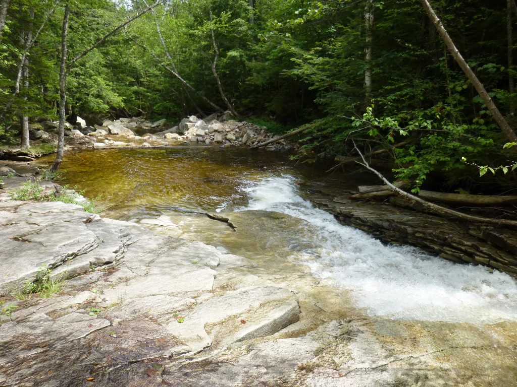 And finally, we got back to the car
about 1:15 - the parking area had "grown" considerably as people wiggled
their vehicles into corners and along the side of the road.
The area
around here is much more crowded than we found in Vermont.
I'm not
sure if this is because these sites are more popular, it is now later
in the summer or it's a weekend: possibly all three!). And finally, we got back to the car
about 1:15 - the parking area had "grown" considerably as people wiggled
their vehicles into corners and along the side of the road.
The area
around here is much more crowded than we found in Vermont.
I'm not
sure if this is because these sites are more popular, it is now later
in the summer or it's a weekend: possibly all three!).  Next we drove over Bear Notch Rd - not
as steep as some other notches we’ve been across this trip, but it is
still posted "closed in winter." To the right is one of the
views from a pullout along the Notch Road. Next we drove over Bear Notch Rd - not
as steep as some other notches we’ve been across this trip, but it is
still posted "closed in winter." To the right is one of the
views from a pullout along the Notch Road.  That took us to NH 112, aka Kancamagus
Hwy, and very shortly to Sabbaday Trail on the right. This
was a nice level, wide trail and only about .3 miles.
Sabbaday Falls is quite interesting - there was no way to get it all in
one picture!. There was a small falls, a pool, a larger
falls, then a turn and 2 levels squeezing through a gorge to another
pool with amazingly clear water (left picture). That took us to NH 112, aka Kancamagus
Hwy, and very shortly to Sabbaday Trail on the right. This
was a nice level, wide trail and only about .3 miles.
Sabbaday Falls is quite interesting - there was no way to get it all in
one picture!. There was a small falls, a pool, a larger
falls, then a turn and 2 levels squeezing through a gorge to another
pool with amazingly clear water (left picture). Below from left to right: a shorter falls, pool and then longer falls in the foreground; in the center is a side view of the shorter falls and you can see it actually starts higher up and turns ; finally, on the right is a view looking down from near the top - you can see some of the twists and multiple levels! 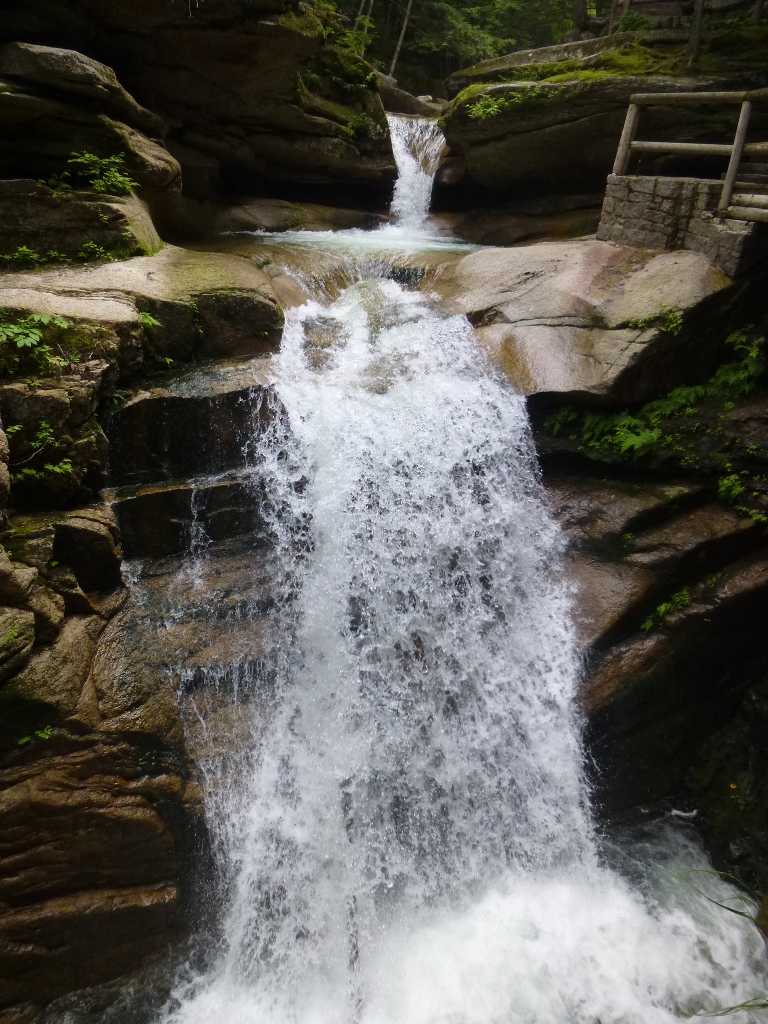

  At the left is a view
along the trail to Sabbaday Falls. The smooth rocks and lots
of green made even the short walk interesting and relaxing. At the left is a view
along the trail to Sabbaday Falls. The smooth rocks and lots
of green made even the short walk interesting and relaxing.  And we enjoyed the many different
views of the falls. And we enjoyed the many different
views of the falls. Next we thought we'd stop at Lower Falls, but the parking lot was totally full and we weren’t that excited about it anyway; so we backtracked 2 miles to Rocky Gorge. That was another waterpark sort of area. It was posted "no swimming" all over but people were out on the rocks, lying in the sun, kids wading in the small pools, and just having a good time. To the right is a view from a small bridge over the Swift River at one end of the recreation area. Below are two other views of some of the falls, cascades and rock formations in the area. John collected some driftwood and then we went back over Bear Notch Rd to our Inn - way easier than going through all the congestion in the Conway area. 
 Back at Will's Inn, we sat on the patio in the cool evening and watched kids have fun in the pool. When it began to get dark we moved indoors, read a little and went to sleep early! Exercise does that to me. Sunday July 14 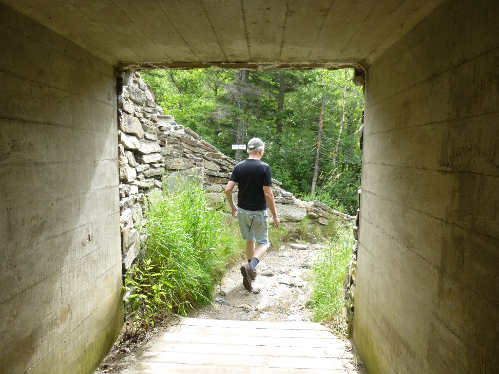  We were a little slower getting off this morning but not
much. Again our first stop was White Mountain Cider Co -
for a
sandwich for John and a muffin for me. (I made my own turkey
wrap) and then headed north on Rt 16. Our first hiking stop was
Glen
Ellis Falls. Parking was on the west side of the road and the
trailhead on the east so there was a tunnel under the
highway for safe access (picture at left). This was a relatively
flat, wide trail along the
Ellis River; there were lots of interesting rocks and cascades (right
above) along the way. The falls had several stages – at left below is
the upper portion emptying into a lovely pool and at the bottom of that
picture you can see the plunge starting down; a view from the bottom of
the main falls is shown at the right. The pool here is very clear
and it felt good to be sprayed on a hot day!
We were a little slower getting off this morning but not
much. Again our first stop was White Mountain Cider Co -
for a
sandwich for John and a muffin for me. (I made my own turkey
wrap) and then headed north on Rt 16. Our first hiking stop was
Glen
Ellis Falls. Parking was on the west side of the road and the
trailhead on the east so there was a tunnel under the
highway for safe access (picture at left). This was a relatively
flat, wide trail along the
Ellis River; there were lots of interesting rocks and cascades (right
above) along the way. The falls had several stages – at left below is
the upper portion emptying into a lovely pool and at the bottom of that
picture you can see the plunge starting down; a view from the bottom of
the main falls is shown at the right. The pool here is very clear
and it felt good to be sprayed on a hot day!    Next on our list was Crystal Cascades – the trail starts behind the AMC
Pinkham Notch Visitor Center. That area was very
busy. In fact, when we got there around 10:45, the parking
lot was completely full. Fortunately, there is an adjacent
NFS lot that was available and a nice pedestrian bridge (left) over the Ellis River links the
two lots.
Next on our list was Crystal Cascades – the trail starts behind the AMC
Pinkham Notch Visitor Center. That area was very
busy. In fact, when we got there around 10:45, the parking
lot was completely full. Fortunately, there is an adjacent
NFS lot that was available and a nice pedestrian bridge (left) over the Ellis River links the
two lots. The trail to Crystal Cascades also goes along the Ellis River - some of the cascades are shown at the right; it's steep but not too bad, partly because it’s short! At the end a steep rock staircase took us up to a great viewing point.  Again, there were several
stages of the falls – a long plunge, a pool then two smaller falls (a
rock separated the flow into two parts). As much as I could fit into one picture is shown at the left. Again, there were several
stages of the falls – a long plunge, a pool then two smaller falls (a
rock separated the flow into two parts). As much as I could fit into one picture is shown at the left.  At right, below, are some persistent ferns that were growing in the rocks right by the viewpoint. At right, below, are some persistent ferns that were growing in the rocks right by the viewpoint. We stopped in the Visitor Center: John bought some more hiking socks and I talked to the trail advice volunteer about a possible short hike nearby. He pointed us right across the street to the Lost Pond trail that’s only about .5 mi and relatively flat. We ate lunch at their picnic tables then walked to Lost Pond over part of the Appalachian Trail. From left to right below: John stopping along the Ellis River on the way to Lost Pond to check out the rocks; at Lost Pond; some not-quite-open water lilies.     Most of the water lilies
weren’t blooming yet but it was a good place for me to sit and eat
another piece of lunch (half of my muffin). Had we looked
more carefully at the map this morning we would have seen that Glen
Ellis Falls and Lost Pond and Crystal Cascades would make a nice loop -
they are all linked by various trails. In fact, we also could
have walked up to the Thompson Falls trail which was less than a mile
from the Visitor Center but it was a very hot day and we didn't need to cook any longer! Most of the water lilies
weren’t blooming yet but it was a good place for me to sit and eat
another piece of lunch (half of my muffin). Had we looked
more carefully at the map this morning we would have seen that Glen
Ellis Falls and Lost Pond and Crystal Cascades would make a nice loop -
they are all linked by various trails. In fact, we also could
have walked up to the Thompson Falls trail which was less than a mile
from the Visitor Center but it was a very hot day and we didn't need to cook any longer! So, we drove up to the Wildcat Parking area where the Thompson
Falls Trailhead is. Wildcat is run by a concessionaire – they
have a zip line (using what are ski lifts in the winter) and a gondola
ride up Wildcat mountain. The place was pretty busy but we
were there for hiking this time. We found the Wildcat Way
Nature Trail easily and that led us to the Thompson Falls
Trail. Once again, there were lots of small cascades along the trail as it followed Thompson Brook (right). So, we drove up to the Wildcat Parking area where the Thompson
Falls Trailhead is. Wildcat is run by a concessionaire – they
have a zip line (using what are ski lifts in the winter) and a gondola
ride up Wildcat mountain. The place was pretty busy but we
were there for hiking this time. We found the Wildcat Way
Nature Trail easily and that led us to the Thompson Falls
Trail. Once again, there were lots of small cascades along the trail as it followed Thompson Brook (right). 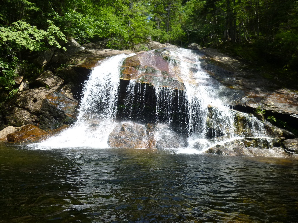 The lower falls is a clam shell fall (left) – wow, it felt
air conditioned sitting there by the pool! Then we hiked further up
along the river to the middle falls which was a twin flow (right); The lower falls is a clam shell fall (left) – wow, it felt
air conditioned sitting there by the pool! Then we hiked further up
along the river to the middle falls which was a twin flow (right);  finally we
crossed the Thompson Brook on rocks to see the upper falls which was a
long plunge plus cascades. I didn’t take my ibuprofen right
away today - forgot about it due to lack of pain (which was good) but now my
ankle was making itself felt so I sat in the shade by the middle
falls and waited while John climbed up and took pictures of
the upper ones. Two good views are below. finally we
crossed the Thompson Brook on rocks to see the upper falls which was a
long plunge plus cascades. I didn’t take my ibuprofen right
away today - forgot about it due to lack of pain (which was good) but now my
ankle was making itself felt so I sat in the shade by the middle
falls and waited while John climbed up and took pictures of
the upper ones. Two good views are below. All was well until, on the way back across the brook above the middle
falls (behind the big rock in the picture above, right), my foot slipped on what looked like a wet boulder but was
actually very slick moss and I slid down a long flat
rock. Fortunately, I was able to stick my foot out and stop
myself so I didn't go over the falls to the right of the rock. But one of
my hiking poles did.
All was well until, on the way back across the brook above the middle
falls (behind the big rock in the picture above, right), my foot slipped on what looked like a wet boulder but was
actually very slick moss and I slid down a long flat
rock. Fortunately, I was able to stick my foot out and stop
myself so I didn't go over the falls to the right of the rock. But one of
my hiking poles did.  Since I was walking over rocks, Since I was walking over rocks,  I was just
holding the poles til I got to the other side. I hung onto
one but the other got away; though it seemed it should be stuck between
rocks or in the pool below, we couldn’t find it. I was just
holding the poles til I got to the other side. I hung onto
one but the other got away; though it seemed it should be stuck between
rocks or in the pool below, we couldn’t find it. I did get very wet and muddy and I jammed my ankle (ouch) but no serious damage was done. The water was quite cold so the ankle was "iced" pretty quickly, but it remains to be seen if I can walk tomorrow! It will be mostly a travel day anyway – on to Maine to visit friends. (Later note: When we went to Black Mountain, NC in August I was able to get an exact replacement pole at the General Store where I originally bought them! I love that store - there's not much they don't have there.) John cooked supper on the camp stove on one of the picnic tables out front by the pool – an Italian concoction using up various leftovers and some additional sauce and veggies. It was very yummy. While he cooked, I showered and changed and my pants and t-shirt dried in the sun while we ate. Last stretch of the trip in the next section. Click here
to go on to Part 4 of our trip.
|